Welcome to the Weekly Creel, a compilation of regional news and announcements for anglers and outdoor enthusiasts of the Chesapeake Bay region. Please email us directly at editor@reelchesapeake.com to have your organization’s news item or event listing considered for next week’s column. Per usual, here are direct links to the lastest, local fishing reports from Reel Chesapeake, On The Water, Maryland Department of Natural Resources, Anglers Sports Center, and FishTalk Magazine. This week’s catch also includes…
New Maryland Record Snakehead!
Anglers began hearing the chatter a few days ago that a potential new, state record northern snakehead had been caught. Online forums and social media chat rooms were buzzing with the news. “Snakeheads” (let’s give diehard snakehead anglers this moniker, perhaps) were speculating who, where, and how big the catch could be. Was it west side or east? Blackwater? Larger than 20 pounds?
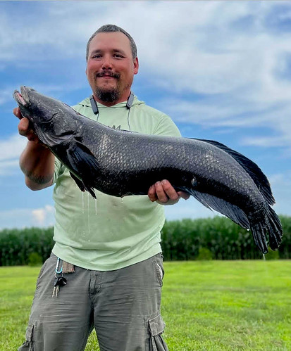
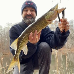
Well, the news officially broke yesterday by the Maryland Department of Natural Resources that, yes indeed, a record fish was landed this past week. “Damien Cook of Rhodesdale has been recognized by the Maryland Department of Natural Resources as a new state record holder for Northern snakehead—Channa argus—in the state’s Invasive Division. Cook caught the 21.0-pound fish on July 5 while fishing in a Dorchester County river.”
According to DNR, “The impressive fish, which measured more than 36 inches long, was weighed on a certified scale provided by Kool Ice Seafood in Cambridge. The species was confirmed by a Maryland Department of Natural Resources biologist. Cook’s catch surpassed the previous record 19.9-pound snakehead caught in 2018 by Andrew D. Fox while bowfishing in Charles County.
“Cook was kayak fishing with a custom baitcasting rod, 30-pound test-rated braided line, and a custom chatterbait he calls the “cooker” when he reeled in the massive snakehead.
“‘Honestly I thought it was just your average 30-inch snakehead when I first hooked the fish,’ Cook said. ‘It pulled hard but I had the advantage of it being close and I got it in the net pretty quickly.'”
The Department of Natural Resources maintains state records for sport fish in four divisions: Atlantic, Chesapeake, Nontidal, and Invasive. Anglers who think they have a potential record catch should download and complete a state record application and call 443-569-1398 to report a potential state record catch. The department recommends the fish be immersed in ice water to preserve its weight until it can be checked, confirmed, and certified. Angler Damien Cook with his state record Northern snakehead. Submitted photo, used with permission via Maryland Department of Natural Resources.
Aerial Survey Indicates SAV Acreage Increase
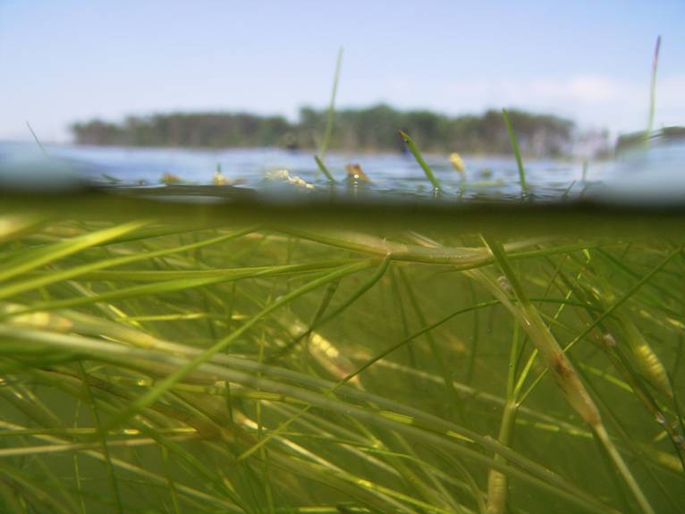
More news from the Maryland Department of Natural Resources. On Thursday, the department reported a 6 percent increase in submerged aquatic vegetation, commonly known as SAV or underwater grasses, in Maryland’s portion of the Chesapeake Bay in 2022. Scientists mapped 37,297 acres of underwater grasses in Maryland during the annual aerial survey. The results represent 47 percent of the state’s 2025 restoration target and 33 percent of the ultimate restoration goal of 114,065 acres.
The Chesapeake Bay experienced moderate to dry conditions in 2022, which may have contributed to the increase. Underwater grasses in all or part of five Maryland rivers surpassed their restoration goals. These included the Northeast River at 111 percent; the Bush River at 112 percent; the upper Gunpowder River at 149 percent; the Wicomico River at 124 percent; and the tidal fresh portion of the Chester River at 507 percent (the percentage of the goal attained is so high due to a very small segment restoration goal). An additional two areas in Maryland reached 75 percent or more of their restoration goals, including the northern Chesapeake Bay and Mattawoman Creek.
Among the notable areas showing positive growth in underwater grasses were the iconic beds in Tangier Sound and the Susquehanna Flats, along with those found in the lower Patuxent River, the Bohemia River, the Little Choptank River and the lower Pocomoke River. In a new development, scientists observed underwater grasses in Cuckold Creek on the lower Patuxent for the first time since the survey began in 1984. Photograph of widgeon grass, which is now the most common submerged aquatic vegetation in the Chesapeake Bay, courtesy Maryland Department of Natural Resources.
Gov. Moore Announces $13.5M for Maryland Waterway Improvements

Yesterday, Maryland Governor Wes Moore announced that the Maryland Department of Natural Resources is providing $13.5 million in Waterway Improvement Funds. The funds will support new and improved public boating access facilities, dredging of navigable public waterways, emergency vessels and equipment for local first responders, and other important infrastructure and initiatives.
“Investing in infrastructure is integral to achieving the full potential of Maryland’s resources,” Gov. Moore said. “This partnership between the Maryland Department of Natural Resources and our local jurisdictions is critical to improving, maintaining, and promoting use of our public waterways.”
The Waterway Improvement Fund is primarily derived from the one-time 5 percent excise tax when a boat is purchased and titled in the state, as well as a small portion of the state gas tax. It has been used to construct and maintain more than 400 public boating facilities and more than 250 public navigational channels across the state as well as the acquisition of vessels.
“Maryland’s Waterway Improvement Fund is an outstanding example of a user-pay, user-benefit program,” Maryland Secretary of Natural Resources Secretary Josh Kurtz said. “Paid largely by Maryland’s boating public, supporting local efforts are critical to this partnership.”
Applications are reviewed and projects are selected based on local government and state needs and priorities, which are evaluated to determine the benefit to the general motor boating public.
Starting after July 15th, the Department of Natural Resources will accept Waterway Improvement Fund applications for the next fiscal year through the department’s online Grants Gateway. For the full list of exact projects that received funding in 2023, click here. Photograph of Gov. Wes Moore by Patrick Siebert, courtesy Office of the Governor.
Assateague OSV Changes Coming?
The Public Comment period for the Environmental Assessment Phase of the Assateague Island National Seashore South Ocean Beach Parking/OSV Entrance Restructuring Plan is now open.
National Park Service has announced that “This project is being considered to improve the safety of the South Ocean Beach area by ending conflicts between parking lot users, walkers, bicyclists, Life of the Dunes hikers, and OSV users. In addition, moving facilities will make the South Ocean Beach recreation area more resilient to natural coastal processes and future storm events, improve safety, and protect and enhance the visitor experience and park resources through visitor use management strategies. Finally, the project will significantly decrease yearly maintenance costs for the parking lot and lessen roadside parking in the South Ocean Beach area.”
The preferred alternative for the plan includes re-routing the Oversand Vehicle Area entrance road to the west side of the South Ocean Beach parking lot, paving and slightly enlarging the parking lot, moving the restrooms and showers to the west, moving the end of the road rotary to the north, and creating a loop at the end of the bike path.
To get the full details of the plan and voice your opinion, please use the National Park Service’s Planning, Environment and Public Comment web site at: https://parkplanning.nps.gov/SouthOceanBeach. Comments can also be mailed to Superintendent, Assateague Island National Seashore 7206 National Seashore Lane Berlin MD 21811.
There will be a public comment meeting at the Assateague Island Environmental Education Center (Park Headquarters) 7206 National Seashore Lane, on Tuesday July 11th between 4 p.m. and 7 p.m. Full details of the plan and preferred alternative will be available at the meeting, along with opportunities to comment and to discuss the project with park planning staff. The public comment period will be open until Tuesday August 1st.
Chesapeake Bay’s “Dead Zone” Decreases
More good news from researchers studying the Chesapeake Bay ecology and overall health. Researchers from the Chesapeake Bay Program, the University of Maryland Center for Environmental Science, University of Michigan, and U.S. Geological Survey recently announced that they are predicting the 2023 dead zone to be significantly smaller than the long-term average taken between 1985 and 2022.
During the spring and summer, nutrient pollution spurs on the growth of algae blooms, which remove oxygen from the water when they die off. These low-oxygen sections of the Bay, known as hypoxic areas or “dead zones,” can suffocate marine life and shrink the habitat available to fish, crabs, and other aquatic life. The dead zone is predicted to be 33 percent smaller than the historic average, which would be the smallest dead zone on record if the forecast proves accurate. The significantly smaller than average forecast size is due in large part to a lack of rainfall in the spring of 2023. Researchers working on the forecast calculated that from November 2022 to May 2023, river flows were 20 percent lower than the average. Less rainfall generally means there is a lower amount of nutrients being washed off the land and into the water.
Scientists calculated 74 million pounds of nitrogen at nine river input monitoring (RIM) stations and 5.2 million pounds were tracked from wastewater treatment plants. This is a decrease from last year when researchers noted 102 million pounds from monitoring stations and 5.7 million pounds from wastewater treatment plants.
While rainfall plays a major role in the size of the dead zone, efforts to limit nutrient pollution in the watershed are also a factor. Maryland, Virginia, Pennsylvania, New York, Delaware, West Virginia, and Washington, D.C., all implement best management practices to reduce nutrient runoff that enters the Bay from sources such as wastewater, agriculture and stormwater. For the past three years, the Bay’s dead zone has been smaller than the long-term average, indicating progress is being made to manage nutrient pollution.
This year, hypoxic conditions began forming in the Bay in mid-May, which is typical. Warm weather increases the likelihood of hypoxic areas forming which is why dead zones tend to last from late May to early fall. In the fall of 2023, researchers will follow up on the forecast with a Bay-wide assessment of the 2023 dead zone size and duration.
And that’s a wrap for this week’s Creel. If you have news to share, please send an email to editor@reelchesapeake.com.